Thursday, March 31, 2011

Pulau Onrust

Wisatanesia.com-Pulau Onrust disebut juga Pulau Kapal. Onrust dalam bahasa Belanda berarti tidak tenang, atau rusuh, mungkin karena pulau ini pernah menjadi perebutan antara Belanda, Inggris dan Portugis. Luasnya hanya 12 Ha namun menyimpan cerita sejarah panjang.

Pulau Onrust sudah terkenal sejak tahun 1618, ketika Belanda menjadikannya sebagai basis penting. Menurut catatan nakhoda kapal Endeavor, Kapten James T. Cook yang singgah di Onrust tahun 1770, di pulau ini terdapat tempat penggergajian kayu serta benteng pertahanan Belanda. Tentara Inggris pernah menyerbu pulau ini pada tanggal 8 November 1800 dan membakar habis semua bangunan.

Tahun 1803, Belanda berhasil membangun kembali semua yang di porak-porandakan Inggris. Pada tahun 1810, tentara Inggris kembali menyerang pulau ini dan memusnahkan semua bangunan Belanda. Namun Belanda membangunnya kembali bahkan lebih lengkap dengan sebuah pelabuhan yang terbuat dari beton.

Pulau ini lalu semakin penting sebagai pelabuhan yang ramai. Peranannya sebagai pelabuhan mulai surut ketika tahun 1883 Pelabuhan Tanjung Priok menggantikan fungsinya. Kemudian, pada tahun 1911, Pulau Onrust beralih fungsi sebagai penjara dan pos karantina penyakit lepra.

Ketika pecah perang antara Jerman dan Belanda tahun 1939, pulau ini dipakai Belanda sebagai tempat pembuangan tawanan. Kini, Pulau Onrust, juga Pulau Cipir, Pulau Bidadari, Pulau Kelor dan Pulau Edam, oleh Pemerintah Indonesia dijadikan sebagai daerah Suaka Taman Purbakala Kepulauan Seribu.Wisata Indonesia Surga Dunia.

Saturday, March 26, 2011

Foto Akad Nikah Krisdayanti ( KD ) dan Raul Lemos

Diva Indonesia Krisdayanti, melangsungkan pernikahan keduanya dengan pengusaha asal Timor Leste, Raul Lemos, di Masjid Sahid Nurul Iman, Hotel Grand Sahid Jaya, Jakarta


Photos by Amateur Model (Camera Phone)


Model : Anna Royani Berutu
Age : 27 Tahun
Camera : Phone ( Samsung , Nokia )

Friday, March 25, 2011

Medan – 10 metropolitan cities in Indonesia

Medan is the capital of North Sumatra province, Indonesia. The city is the third largest city in Indonesia after Jakarta and Surabaya. Medan city has an area of 26 510 hectares (265.10 square kilometers) or 3.6% of the whole region of North Sumatera. Thus, compared to districts other, Medan has a relatively small area with a relatively large population. Medan city geographically located between 3 ° 30th ‘- 3 ° 43′ north latitude and 1998 ° 35 ‘- 98 ° 44th’ east longitude. For the topography of the city of Medan tend to tilt to the north and located at a height of 2.5 to 37.5 meters above sea level.

Medan was founded by Guru Patimpus Sembiring Pelawi in the year 1590. John Anderson, the first European to visit the Deli in the year 1833 to find a village called Medan. This village has a population of 200 people and declared as a place of residence of the Sultan of Deli. In 1883, Singapore has become an important city outside Java, especially after the colonial government opened the company’s large-scale plantations.

JW.Marriot hotels in Medan :

In the field there are still many old buildings from the Dutch. For example: the old City Hall, Post Office Singapore, Water Tower (which is the icon of Medan city), Titi Hanging – a bridge over the railway, and also House London Sumatra.

The uniqueness in Medan is located in the motor rickshaw that can be found in almost all areas of Medan. Unlike ordinary rickshaw (pedicab oar “), motor rickshaws can carry passengers from wherever in the city. Besides rickshaw, in the city are also available in the form of public transport mini buses (public transportation / “oplet ‘) and taxis. Medan different rickshaw pedicab in Jakarta or any other Java towns. Cycle rickshaw pedicab was beside, not behind as in Java pedicab. It’s easy to Medan rickshaw through the winding roads. In addition, this also allows pedicab Medan to be produced with a minimum price, because it only required a small modification to your bike or regular bike can be used as pedicab drivers. This design takes the design of the motorcycle sidecar in German war-second world war.

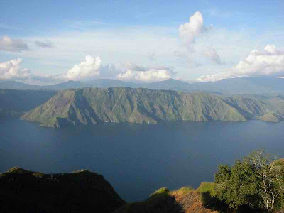
Lake Toba – North Sumatera

Lake Toba is a volcanic lake with a length of 100 kilometers and 30 kilometers wide, located in North Sumatra province, Indonesia. This lake is the largest lake in Indonesia and Southeast Asia. In the middle of this lake there is a volcanic island called Samosir Island.
Lake Toba has long been an important tourist destination in addition to Bukit Lawang, North Sumatra and Nias, attracting domestic and foreign tourists.History
Lake Toba is estimated that when the explosion occurred around 73000-75000 years ago and is the eruption Supervolcano (super volcano), the most recent. Bill Rose and Craig Chesner from Michigan Technological University estimate that volcanic materials of the mountain spit out as much as 2800 km ³, with 800 km ³ of rock and 2,000 km ³ overlies the volcanic ash which is expected in the wind to west for two weeks. Volcanic dust in the wind has spread to half the earth, from China to South Africa. The explosion occurred during the first week and throw dust reaches 10 km above sea level.
This incident caused mass death and also participated in several species extinction. According to some DNA evidence, this eruption also shrink the number of people until about 60% of the total human population of the earth at that time, which is about 60 million people. The eruption was also contributes to the ice age, although experts are still debating.After the eruption, the caldera formed which was then filled with water and became what is now known as Lake Toba. Pressure upward by magma that has not come out cause the appearance of Samosir Island.
International multidisciplinary research team, led by Dr. Michael Petraglia, revealed in a press conference in Oxford, the United States that has found a new archeological site quite spectacular by the geologist in the south and north India. On the site it was revealed how people survive, before and after volcanic eruptions (Supervolcano) Toba at 74 000 years ago, and evidence of life beneath the ash heap of Mount Toba. Though the source of the eruption is 3000 miles, from the distribution of ashes.For seven years, experts from Oxford University is researching ecosystem project in India, to search for evidence of life and the lives they left behind equipment in a barren desert. Wide area with thousands of hectares of this was just savanna (grassland). Meanwhile, animal bones scattered. The team concluded, in large areas is apparently covered with dust from ancient volcanic eruptions.
The spread of volcanic dust was extremely spacious, found almost worldwide. Derived from an ancient Supervolcano erruption, which leads to Mount Toba.Dugaan Mount Toba, because it found evidence of molecular forms of the same volcanic ash in the 2100 period. Since caldera crater is now a lake Toba in Indonesia, up to 3000 miles, from the eruption source. Even that is quite surprising, it turns out that the spread of dust until caught up to the North Pole. This reminds the experts, how powerful eruption of Toba super volcano at the time. Evidence is found, strengthening the suspicion, that the strength of the eruption, and sea waves could wipe out life on Atlantis.

Bunaken Island – North Sulawesi


Bunaken is an area of 8.08 km ² island in the Bay of Manado, located in the northern island of Sulawesi, Indonesia. This island is part of the city of Manado, the provincial capital of North Sulawesi, Indonesia. Bunaken island can be traveled by ship fast (speed boat) or a rented boat with about 30 minutes journey from the port city of Manado.
Bunaken Island Around Bunaken marine park there which is part of the Bunaken National Park. This marine park has a marine biodiversity one of the highest in the world. Scuba diving attracts many visitors to the island. Overall Bunaken marine park covers an area of 75,265 hectares with five islands within it, namely the island of Manado Tua, Bunaken Island, Island Siladen, Mantehage Island follows several children island, and island Naen. Although covering an area 75,265 hectares, the location of dive (diving) is limited in each of the five beaches that surround the island.Bunaken marine park has a 20 point dive (dive spot) with varying depth of up to 1344 meters. Of the 20 diving points, 12 points among them diving around Bunaken Island. Twelve point dive is the most frequently visited by divers and lovers of the beauty of the underwater scenery.
Most of the 12 point dive in the Bunaken Island line from the southeast to the northwest of the island. In this region there are great underwater walls, also called the hanging walls, or walls of a giant rock that stands vertically and curved upward. These rock walls are also a source of food for fish in the waters around Bunaken Island.

Photo airsoft gun

Photo airsoft gun


Design by Wordpress Theme | Bloggerized by Free Blogger Templates | free samples without surveys